Yutika

City of Ram and Kalam

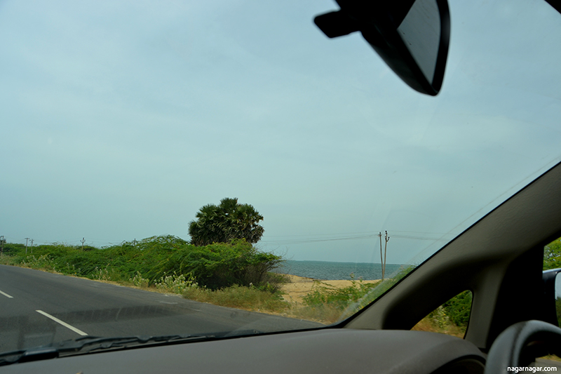
Rameswaram was our southern most point for this trip. We were both extremely excited at the prospect of seeing the ocean again. Both of us have an unsaid competition on who would be the first person to spot the ocean. On our drive to Rameswaram, we were both caught unsuspectingly when suddenly the ocean just appeared next to us (on right side first and then left) beyond the seemingly abandoned buildings less than 50 meters away from the road. 

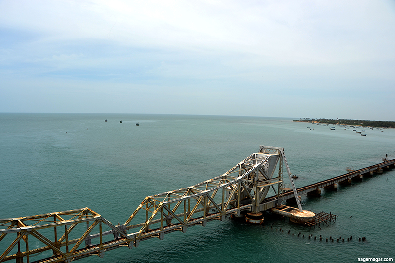
Just as we were getting used to the idea that we had the ocean next to us on two sides, we came upon the Pamban Bridge - connects Pamban Island (on which Rameswaram lies) to the Indian mainland. Pamban Island has a number of small fishing hamlets along with Rameswaram town. The ocean on both sides has is vast with hues of blue, the bridge running parallel to the railway bridge which is running much lower, closer to the ocean.

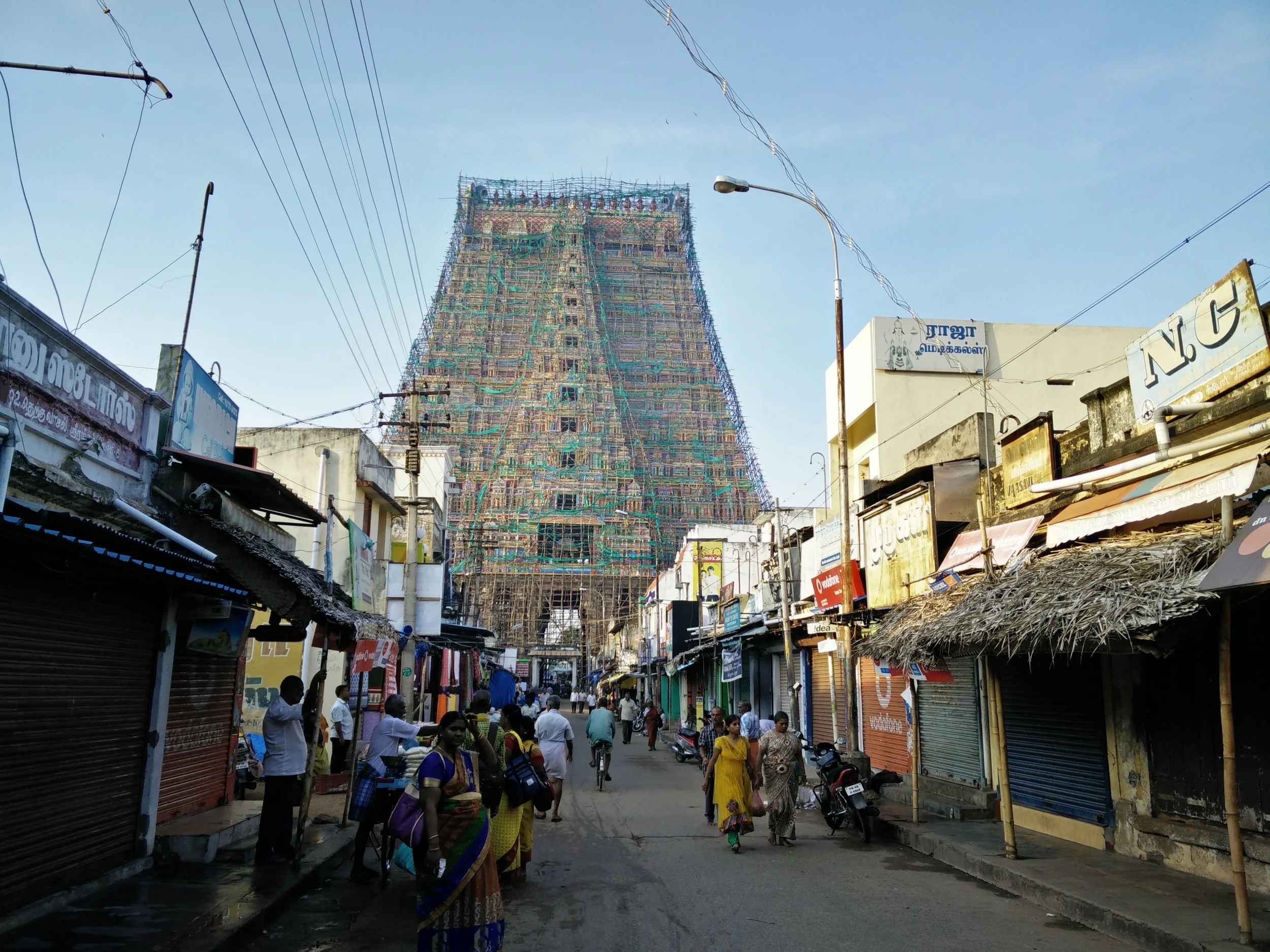
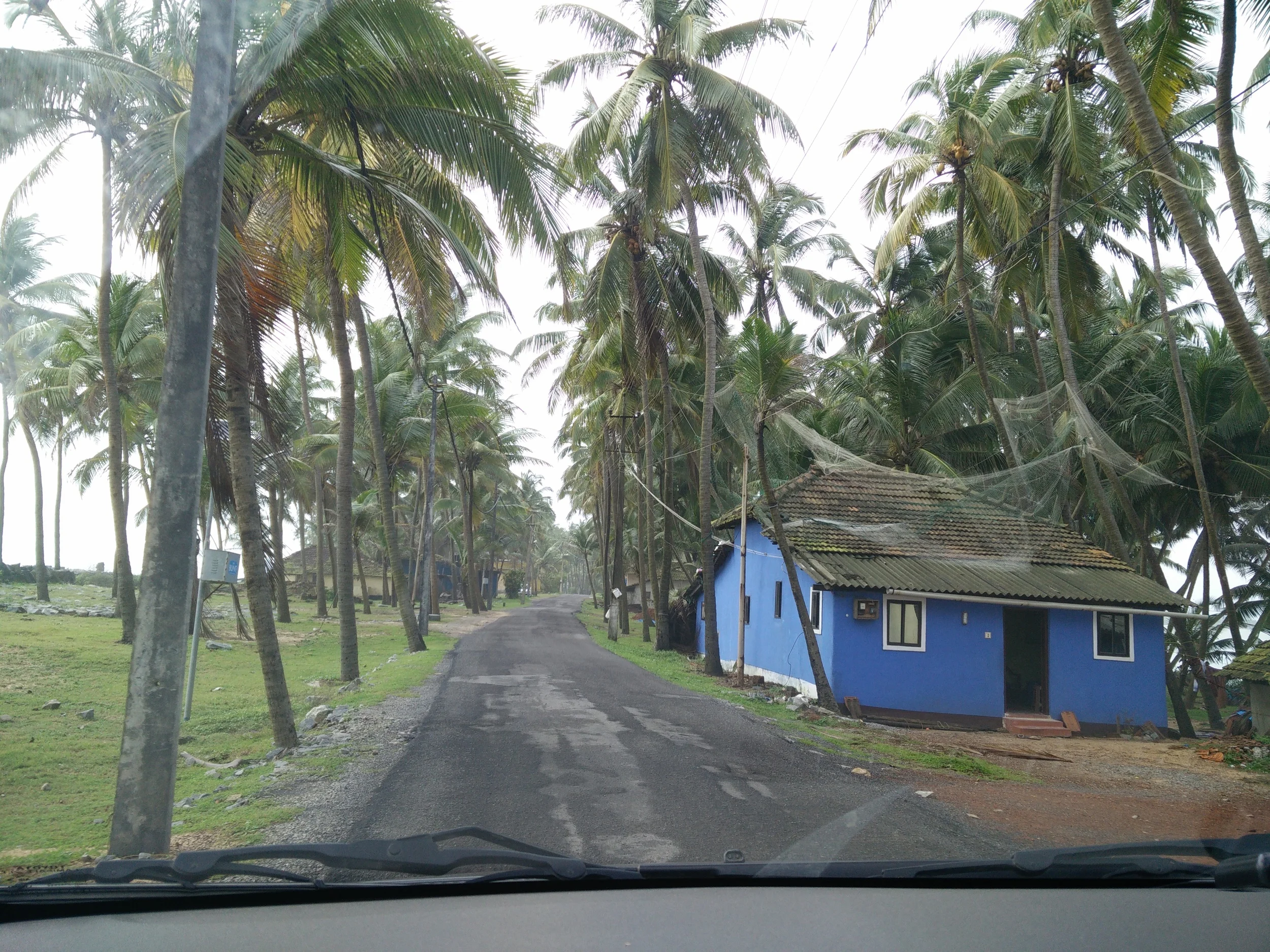
As we drove through the small town of Rameswaram, the town was filled with lodges teeming with pilgrims. It had the small buildings typically seen in villages and other than the yellow autos plying the streets it seemed like an overgrown village. In our attempt to get to our hotel, we got stuck in a narrow alley more than once, sometimes these alleys were also barricaded. Forcing us to reverse through the narrow alleys. We also passed by the site where the late Honourable President APJ Abdul Kalam was recently laid and we paid our homages.

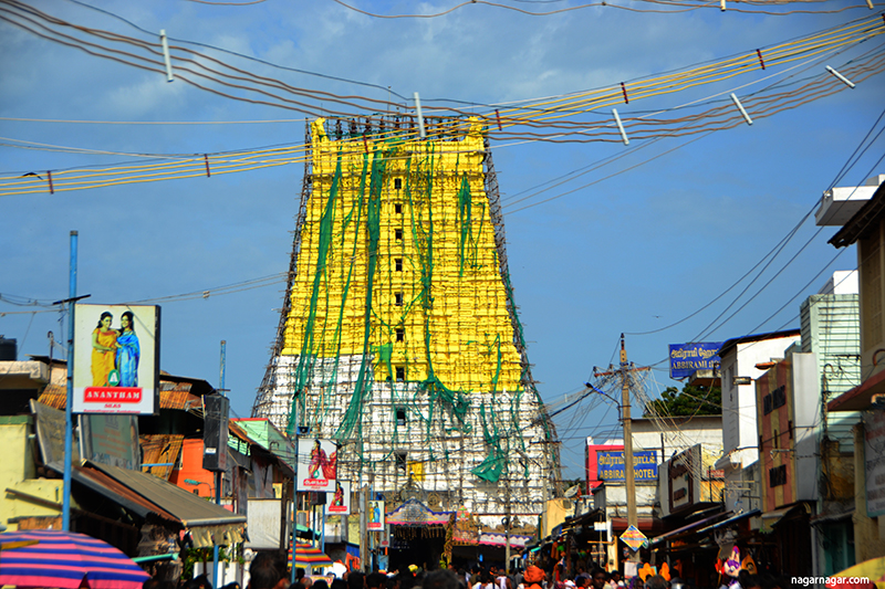
Our stay at Rameswaram was memorable but two experiences were truly outstanding. The first was the full darshan experience at the Ramanatha Swami temple and the second was the drive and the overwhelming feeling of being at the end of land, at Dhanushkodi, tip of the Palk Strait, where one can feel that the next land mass is a different country.

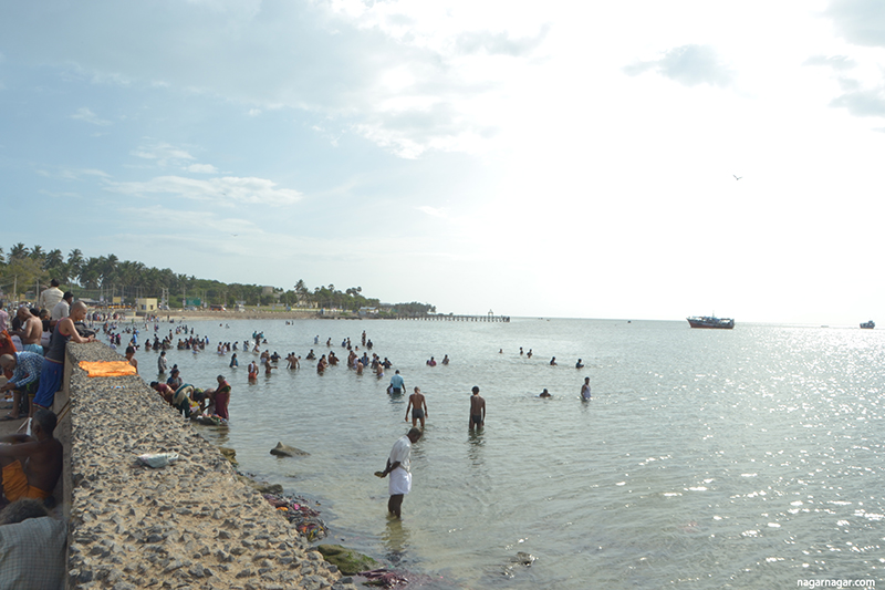
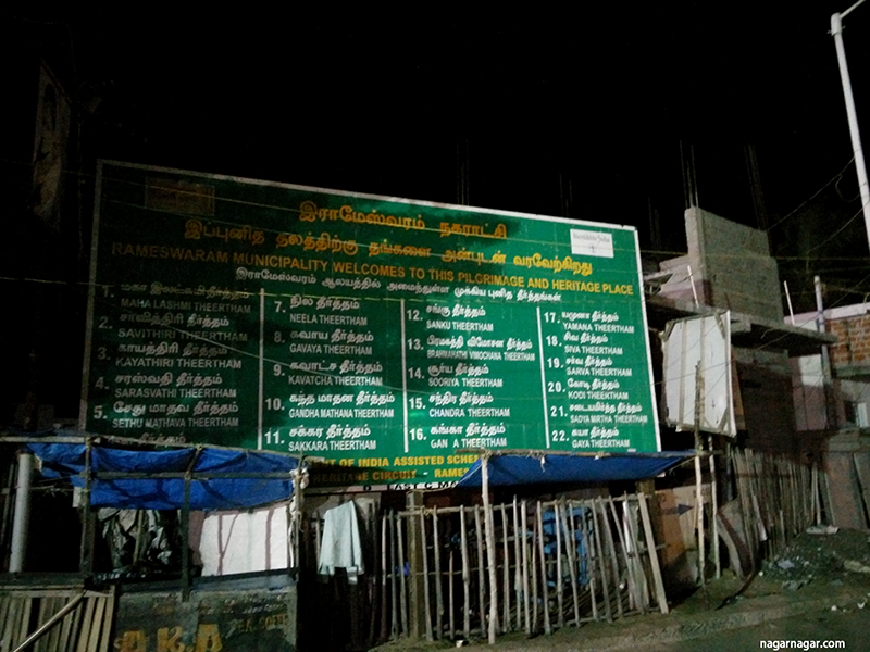
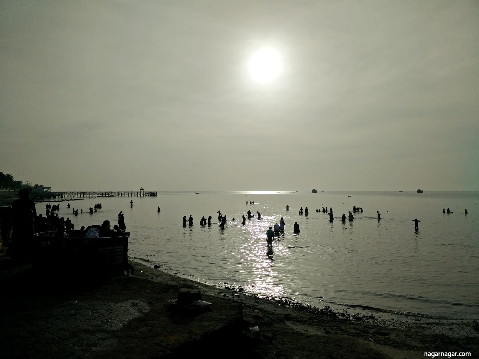
We arrived in Rameswaram in the afternoon and were planning to spend the afternoon just walking around an acquainting ourselves with the city. After a homely meal in one of the small messes, we spoke to a local who suggested that we do the darshan that day itself since the next day would be extremely crowded. There is an specific way to see the Ramanatha Swami temple, which includes bathing in the sea followed by being bathed (pouring a bucket of water) from 22 tirthas (wells) and they drying yourself, changing into a clean set of clothes before appearing before the Shiva Linga at the center of the temple. We found a guide that helped us through the process and proceeded to take a dip in the Bay of Bengal at Agniteertha.

The whole experience of running between wells with different waters (varying both in temperature and as Tarun says taste as well) was surreal. Along with a diverse community of people varying in ages, regions, gender, undergoing the same experience as us, the walk of the wells felt a unifying experience, neutralising a lot of differences. After changing, we progressed to the do the darshan which in itself was powerful. However, the experience and adrenalin rush from the 22 wells was something else. 

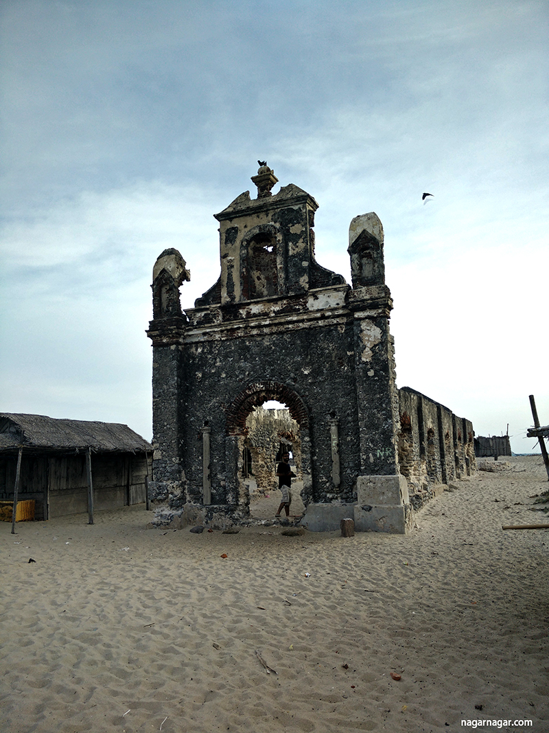
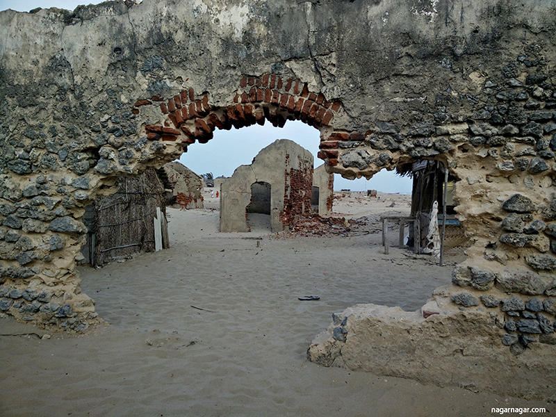
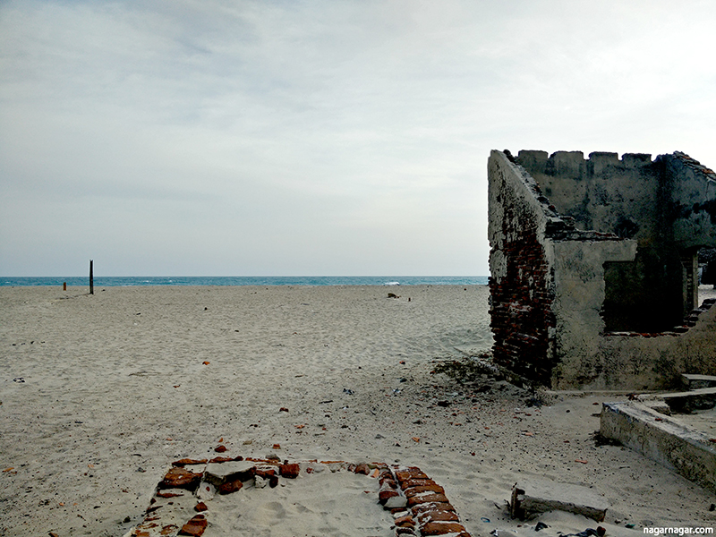
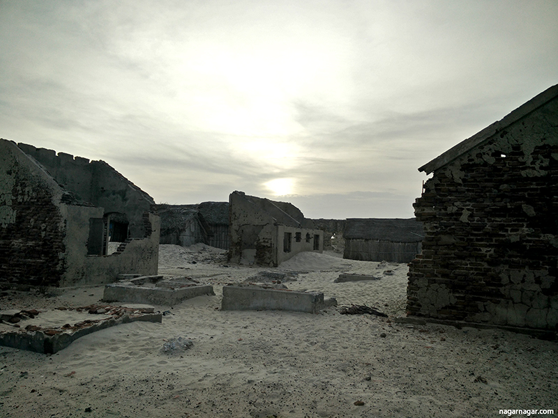
The drive to Dhanushkodi was another overwhelming experience. It was once a bustling border and port town, now reduced to a ghost town, since it got washed away in a 1964 cyclone . The town used to have a train station, post office, customs office, schools and a busy market. However, after the cyclone, the town was never rebuilt and was deemed unfit for living by the government. Now, one can see some of the relics of these buildings. The stones of the track ballast were still visible along what would have been the railway track, though the iron track itself is gone. Access to the town as well as the lands end on the Indian mainland going into the Palk Strait is along the ocean and sometimes even through the ocean. Currently only accessible using the permitted 4 wheel drive jeeps and vans but a road is under construction and should open in the next 6 months or so.

We were not sure if we will be able to get to the point where we are surrounded by water on three sides, with the Bay of Bengal on one side and the Indian Ocean on the other. When the driver did take us there, both of us were taken by the breathtaking view. It was surreal to be at this point that we had heard so much about. It would also be the closest either of us had ever been to Sri Lanka. What was especially intriguing was that the Indian Ocean had waves that rose at least 2 to 3 feet smashing into the beach and just 20 feet on the other side, the Bay of Bengal lay still and calm. It was surreal, unbelievable almost.


Karnataka Kavi: Kuvempu of Kuppalli

The Western Ghat or Sahyadri slopes in Karnataka make the Male-nadu region. 'Male' meaning ‘hill’ or ‘rain’ and 'nadu' meaning ‘region’. Many rivers originate from this region including the Tunga, Bhadra, Kaveri and the Malaprabha. The historic Dharmastala, the famous jog falls, Agumbe ghat (town with 2nd highest and last year the highest rainfall in India and also where Malgudi Hills was shot) are some of the famous places in the Malnad region. The Malnad Cuisine  tastes that we never knew existed but I think that deserves a separate post. 

We hadn’t really expected to do touristy things much during our stay in the hills as we were looking for a place to process all that we had experienced thus far. While we were enjoying the rain  (after a long dry spell of almost 2 weeks) and we were sitting in a little gazebo with a light drizzle all day long, our hosts at the Homestay suggested that we visit the home of the Poet Kuppali Venkatappa Puttappa popularly known by his pen name, Kuvempu. Kuvempu (1904-1994) had been conferred the Padma Vibhushan in 1988 for his contributions to modern Indian literature thought his poems, plays and novels. He is also the writer of the Karnataka State Anthem. While Kuvempu spent most of his adult life in Mysore as a professor at the Mysore University, he spent the first 15 years of his life in the region. 

Kuvempu’s ancestral home is set in the beautiful Malnad landscape. The poet’s 250 years old home has been restored and converted into a museum by the Kuvempu Prathisthana. We were told that the house is a quintessential Malnad house with a courtyard in the middle and jackfruit wood pillars. Interestingly, the house itself is the only house in the village of Kuppalli. 

Just about 6 kilometers from our homestay, the serenity and peace around the house with arecanut plantations in the backyard was calming. There was still remnants of the rain from earlier in the day. The house itself not only kept some of the artefacts and memorabilia of the life of the Poet but it has also retained the architecture of a Malnad home. Malnad homes are built for the monsoon, with their Mangalore tiles and sloping roofs and also the use of jackfruit wood (we were told that jackfruit wood is unique in that it expands very little with moisture, also why it is used to make musical instruments). It also has small rooms, with small windows (protecting from wind and rain) along with traditionally mud walls keeping the house cool during the summer months. However, many of the mud walls were replaced with cement during the restoration. The house gives us some glimpses of what life would have been in this region.

A short walk from the house, up the hill is a vista point from where one can see the surrounding hills and the poet apparently came to sit and think on a particular rock. The expanse of the hills with the green carpet that surrounded us was unlike anything we had seen so far in the region. While I felt at home in Theerathalli, I missed Panchgani’s clear view of the valleys and surrounding mountains from most of our drives. Because we were so deep in the midst of trees and the gradual slopes around us at any point we didn’t know how high we were, whether we were on top of a hill or in a valley. 

I have not been able to find many English translations of his poetry but was told that this serene and green geography seems to come up in many of his poems. This is the one that I found called “Oh mother, Blessed am I, to be born to you”.

Oh mother, Blessed I am, to be born to you
Blessed is my soul, to be nourished by your love
I don't care if you are adorned like a queen
I don't care if thou grant every wish, like Surabhi
All I know is my courtyard is filled with the fragrance
Of your sacred presence
Of the criticisms about your lacking, I am aware
The ridicules of being backward, you had to bear
Those adorned by gold, I shun
I regard you as the glorious one
In the luster of your eyes I open my eyes
With joy I'll grow in your holy land
Thy glory I'll pen; thy name I'll call
For the fortune of your service, I reject all


Ratnagiri: Economies of Geographies

Ratnagiri made it to our list of cities partly because of a unique feature of its history highlighted by Amitav Ghosh in The Glass Palace and partly because of its proximity to Panchgani. The drive from Panchgani to Ratnagiri through the picturesque route of the Sahyadri mountains down the Mahad ghat sealed the deal of starting our nagarnagar travels with Ratnagiri.

Ratnagiri, a small sleepy Konkan town on Maharashtra’s coast, is considered the largest coastal city between Mumbai and Goa. Its beautiful landscape consists of breathtaking ocean waves crashing into jagged mountain cliffs at high tide with surreal rock formations exposed during low tide contrasted with the green estuaries just 500 meters away.

Each of these geographical features, the mountains, the estuaries as well as the coastline provide a unique economic history to Ratnagiri. The laterite rock plateaus along with the red iron rich soil provide the perfect soil for the world famous alphonso mangos. In our discussions with a local geologist, he explained that the unique taste of these mangoes comes as a result of the iron content in this soil. The plateaus also provide the perfect climes for cashews. Cashew orchards are interspersed amongst the mango farms.

The estuaries were navigable until 1985 providing the only means of travel to towns like Harchiri and Rajwada. The road networks have only developed over the last two decades. With the roads developed and the silting of the many of the estuaries, the waterways have become mostly defunct other than the odd fishing boat and a couple of small river crossings. But this network of waterways has historically meant that locals are well versed with ship-building. Historically, artisans from Ratnagiri were hired by the British for ship-building and are still hired around Belgaum and Kolhapur for their carpentry skills.

As these traditional occupations are on the wane, with mango and cashew being seasonal, there has been a spurt of a peculiar kind of service industry. Ratnagiri, a town of merely 70,000 persons, is home to at least fifty banks, many of which that have recently established branches. This business seems to be thriving partly to do with another aspect of Ratnagiri’s history and geographical location, its remittances. Through the 1900’s, Ratnagiri has acted as a key source of labour for Mumbai’s growing business and service industries. Given the similarity in language and geography, there has been a strong economic linkage between the two cities with every household from Ratnagiri has at least one person in Mumbai.

Even though Ratnagiri has a number of universities few of the skilled graduates stay in Ratnagiri. Mainly those with a family businesses continue to stay in Ratnagiri, many others are still migrating to Pune, Mumbai and Bangalore. However, we met a couple of young men that have made their way back from Mumbai to set up a tech startup in Ratnagiri. Their allure for Ratnagiri were the short (10 minutes to anywhere) commute times, clean air and generally living in Ratnagiri. They explained that the benefits of living in Ratnagiri were far more than the challenges of living in Ratnagiri especially when compared to life in a metro. 

Would we have gotten lost without Google maps?

In the past month we have driven about 2500 kilometers through six states (New Delhi, Haryana, Rajasthan, Gujarat, Maharashtra and Karnataka) on all types of roads – national highways, state highways, village roads, city roads and non-existent roads.

Navigation has been made significantly easier by Google maps and mapmyindia. For us, the little pre-planning for the trip was possible only because of Google maps. This tool gave us a lot of courage that other than asking the next person walking on the road, finding our way would be not so difficult most of the times and allowed us to make plans. That said,  the charm of getting lost is lost in this age of Google maps. So whenever we hear the hopeless declaration 'GPS Signal Lost', we know that we are going to end up on something unexpected - which is not always a bad thing. We ended up on the other side of the grand Gokak falls that had an amazing view of the entire fall and the valley ahead. Using our all knowing GPS maps, we drove to Gokak falls, and at the time that both of us thought that maybe we have been led astray since we seemed to be driving through fields and villages without any sign for a fall, we suddenly found ourselves looking at the fall at a deadend-except that we were on the side of the village rather than the side where the Gokak mill and parking area is. It made for a spectacular view that we may have otherwise missed. There is a joy in getting lost indeed.

There is a sense of comfort in having this crutch especially given the dearth of signage on most roads. It was inconsistent, even on some national highway, that we found key signage for bypasses, intersections, and roads into cities. There have been many turns that we would have surely missed if it wasn’t for Google maps.  For those seeking an adventure, it may not be undesirable to miss a turn but for those who are trying to get from City A to city B, these missing signposts may turn out to be a lost half hour or many kilometers lost. So far, we havn’t been completely lost, between Google maps and common sense (once it tried to send us over a wall) we have kind of managed to figure out our way even though sometimes it may be a much longer way or a road barely wide enough for our car to pass.

In India, most often we are able to find someone to ask directions from so getting lost may not be the worst thing. But the lack of signs can affect us in more ways than just making us clueless or lost. Road signs also alert the driver about an intersection, a diversion, or simply a indicate a speed breaker. These vital signs were missing on most highways except a couple of the main NHAI (golden quadrilateral) highways. When we think of road safety in India, we often associate it with reckless driving. But improved road signs may be a simple way to at least alert cautious drivers about possible road blocks or turns or more simply, just provide us signposts regarding our destination.